All inclusive cost
20 Days 19 Night
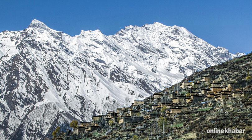
Limi Valley Trek is located at the western part of Nepal. Most of the people in Humla District follows Tibetan Culture. The Limi Valley trek was only opened to foreigners in 2002 as this area borders on Tibet in the far west of Nepal. It is follows an ancient trading and pilgrim route over challenging trails and high passes. This is one of last true wilderness area, tucked away inside. Humla District where century old Buddhist traditions still exist and the people of the north-western part of the district are more like their Tibetan neighbors to the north than their Hindu neighbors in the south-east part of the district.
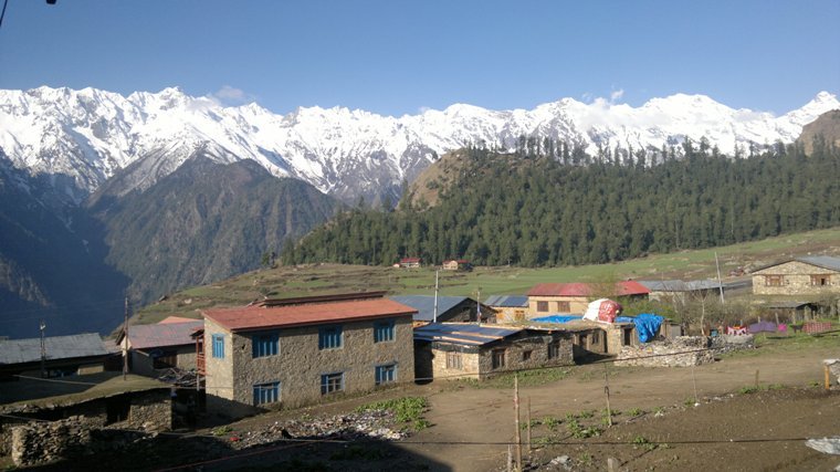
On this trek, not only can hikers see the great mountains of Saipal, Byas, Rishi, Api, Kanjirowa, and Kanti in Nepal, but also the revered holy Mount Kailash across the border in Tibet. Possible wildlife on view includes marmot, wolf, wild yak, and Himalayan black bears. This amazing trek highlights a different side of Nepal than that seen in some of the more usual trekking routes. It also gives a glimpse into the mystical land of Tibet. The major highlight of Limi Valley Trek involves the trek up to Gyuo Kharka 5150 m, which caters an opportunity to sight the view that would make you fall in love with the beauty of nature and there snow leopards and blue sheep are known to live. Lower Dolpo Trek
From the top of this pass, we see breathtaking beauty of alpine nature that include Himalayas like Saipal (7031 m), Byas Rishi, Api, Kanjirowa, Kanti, Gorakh Himalayas. The beauty nature from here stretches until the Himalayan Peaks in Tibet, which include sacred Peak, Mt. Kailash and Gorlamdanda. The view of Lake Mansarovar lying at the foothills of Kailash is enchanting view. Rara Lake Trek
Day 01 : Arrival at Kathmandu (1345 m)
Arrive at Tribhuvan International Airport in Kathmandu; you will be pick up check in Hotel. where you can go shopping, tour durbar squares.
Day 02 : Trip arrangements, meeting with staff and Perpetration for the Trip
This is your second day in Nepal; we introduce the Guide and other staff and organize permit and paper work. While organizing restricted area permit, we need your Nepal visa which must be validate entire trip and original passport with 4 copy of PP Size pictures each of you. So, normally it is not possible organized all your permits before your Nepal arrival, according to Nepal immigration rule. Or you may explore to the Pashupatinath Temple, Boudhanath Stupa, Swayambhunath Stupa and Durbar Squares and shopping for the trekking.
Day 03 : Flight Kathmandu-Nepalgunj, 1 hour
Today, you will fly Kathmandu to Nepalgunj. There is not direct flight Kathmandu to Simikot, so at list you need to stay one night in Nepalgunj before you catch a plane to Humla. Nepalgunj is a business hub for both the city dwellers and those who live high mountains. As Nepalganj is just five miles (8km) by Indian border, so the traditional and culture is similar like Indian. And it comes as no surprise that it looks more like an Indian city than it is a Nepali one. Nepaljung is Terai region the temperature is high here and the condition humid for most part of the year. You will check in to the hotel for an overnight stay.
Day 04 : Flight Nepalgunj-Simikot (2950m), 45 munities
Today you will fly to Simikot. It takes about 45 minutes flight from take off to touch down from Nepalgunj. The flight is a amazing through the ridges and ravines in the spectacular mountains. Landing at the Simikot Airport is no less adventure as it is just a graveled airstrip but it has planning to become asphalt soon. You feel like you are in a different world due to the sudden rise in altitude and decrease in temperature. The high mountains climate with fresh air makes your breathing cool and fell refreshing. You are staying night in the tented camp or you can stay at Guest House.
Day 05 : Simikot to Dharapuri(2300m), 4 – 5 hours
This is you first day trip. After hot breakfast day starts with the hike to a pass (3,150m) which is approximately an hour. Then the trail is a descent of about an hour to Majgaon. Mostly the trail goes through the pine forest where you can see local Hindu and Buddhist people in their traditional dress accompanied by their herds of cattle. Cattle are main transportation modes in this area. They carry the load for the people in this part of the world because there is no motor able road. If people have not their cattle then people carry their loads on their backs with head strip and take them to destination. When you passing Majgaon, the trail get rough; one corner it is descent and it is ascent the next corner. Some people called Nepali flat for this particular topography. At higher you have green and lush scenery. When you decide to call it a day, your night will be spent in a tented Camp.
Day 06 : Dharapuri to Kermi (2670m), 5 – 6 hours
Today the trail goes through the Karnali River Side with unusual one for some in that the track keeps altering the elevation within matters of a couple hundred meters. Sometime the trail goes through the narrow gorges of Karnali River with high rocky slopes and there will be moments when you find yourself walking right at the bank of the river. Then you will walk by pattern of cultivation land by local. They grow barley, buckwheat, potatoes, bean and rice and doing animal husbandry. Today you will enjoy hot spring at Kermi after 30 minutes hiking. People of here and further above are following the Buddhism, you can see Monastery and Chorten with beautifully craft Mane wall every village. There are popular two monasteries, Lakiyo Gompa and Lhundrup Choeling Gompa. The first one was from few hundred years old, within 45 minutes walking distance from the camp. To get latter one takes 30 minutes from the camp, is relatively new and was built less than a century ago. The trekkers not often visit the monasteries, but you may batter you visit this for new experience.
Day 07 : Kermi to Yalbang (3020m), 4 – 5 hours
Today the trail is more easer. Except a small pass, most of the trail to the Yalbang is flat with nice scenery alongside the fields with different species of lizards and other creatures. The walk on big iron suspension bridge over the Sali River will be great fun for your journey. From here the trail descent from this point forward. You might want to stop few minutes for sipping tea and coffee nibbling some cookies. The trip is better from here as there are beautiful pine and rhododendron trees above your head and bright green Karnali down the hill. As cattle are main transportation means of this area, you do not be surprised if you bump by caravans of mules and Dzomo (hybrid of yak and cow). The local villagers are travelling for trade from Simikot to Nyinba Valley and Taklakot. This is main trade hub across the Tibetan border.
In the Yalbang village, there are many places and heritages site to spend extra days as explore. You may visit to the Namkha Khyung Dzong Monastery. The monastery is ancient structure with beautiful craving and Tibetan mantra at wall. This is one of the biggest monasteries in the region where are about 130 monks living. The monastery originally comes from the Nyingmapa Lineage, the oldest Buddhist lineage. According to the legend it was founded by Guru Rimporche in 7th century, who is a great magician. Inside the monastery there is a huge statue of Shakyamuni Buddha and other smaller statues along with that of Guru Rimporche. There is Buddhism school and a clinic. You may participate for praying ceremony in the monastery which is happened at every morning and noon. You will soak with the spiritual vibes by being a part of the ritual.
Day 08 : Yalbang to Muchu (3120m) 4 hours or Tumkot (3380m), 4 – 5 hours
After having breakfast, the journey continues on as we catch up with the trail from where we left off. The trail is heading to the Yangar village where the Karnali River leaves below. Today most of the path is flat except at some parts of the journey there are three sided tunnel like trails that are fixed out of huge boulders. The climate is change every half or an hour walking. The greenery begins to disappear and so do the smaller bushes. The pine forest finished here and appraiser huge part of rocky hillocks. Then, you will across the big wooden suspension bridge over Karnali River. Begin to climb through the Rocky Mountains, where the party is only getting started and you can tell that by looking. The trail continues to climb until it reaches the climax of the deep gorge. You flow emerald green Karnali bottomless under the gorge still embraces the same charm and continues to keep you a company. Do not need to be surprised, when you witness ancient trade methods still existing in same old fashion like the sheep carrying the sacks of salt on their backs. Then, trail goes through the army camp and stop for the quick tea coffee with snacks.
It takes 3 to 4 hours to get t in Muchu village. If you have energy left, we heading to Tumkot about additional an hour walk. Tumkot is beautiful village; where the main trail breaks down two parts for a small market. The north part of the same market is Tumkot. If walk 20 minutes on top of a rocky mountain, you get in Dhungkar Choezom Monastery, which is affiliated to Shakya Lineage. This is considered one of the important monasteries in the Tibetan region. This is the only Shakya monastery in Humla districts. Should the warden of the monastery be available he will give you insight on every minute detail that the monastery has in its bosom.You will stay overnight in a tent.
Day 09 : Tumkot to Yari (3700 m) or Thado Dunga (3750 m), 4 – 5 hours
The track of today continues to go up and steeper with similar climate, vegetation and the landscape. After a few hours hike the climate begins to change. The landscape becomes more rocky and barren despair green pine trees and starts to see short and low junipers. You have sight of under construction trail. Further more on the end of the road brings you to the Pani Palwang village with some tea houses. This place is a perfect for the lunch break. From here the Yari or Thado Dunga is just an hour and half.
Day 10 : Yari to Hilsa (3720 m), across the Nara La (4,560 m), 6 – 7 hours
Today the trail is quite harder; we need to cross Nara La Pass an elevation of 4,560 meters. The trees are despair and start to see dry marine land with beautiful landscape looks more like that of Tibet. Often you will see herd of Dzopas, Mules and Yaks on the trail. Especially yaks with huge body and long hair interested to see. The trail from Thado Dunga is steeper and harder. Often you might want to stop for a cup of tea and water enjoying with beautiful scenery. To get in top of Nara La, there is still two more hours. Today you might see some snow on the trail as first time of the trip. The trail for today will just half after the top. On the top you can see the piles of stones, and Buddhist prayer flags looming in the air, this is symbol of bring good luck on you. Furthermore, you are captivated the breathtaking view of Tibet on the one side and spectacular view of Yari Village down below. Beautiful landscape with barren mountains in brown, copper, ash and dark yellow colors as far as you can see. The rest of the trail from here is an unstable descent down until Nepal.
Day 11 : Hilsa to Manepeme (3900 m), 5 – 6 hours
You will leave the Hila after cross the big iron bridge over the Karnali River, some time there is traffic jam of donkey and trekkers. Then, walk along a narrow trail that winds its way up until you connect with the main route on the higher hill. Again the trail fallows the Karnali River all the way to Manepeme. Most of the trail today is up and down, this will be perfect training rest of the trip. Due to amazing landscapes, jungle and barren mountains blow your mind away and you won’t fell tired. And no prizes for guessing, you will be spending your night in a tent.
Day 12 : Manepeme to Til (4000m) 5 – 6 hours
This is your day twelfth of trip, still you need to climbing up continues. After couple of hours walking you will choose a small path that stays at the same level for a while and the wider path that starts going up instantly. This narrow trail takes you to a very old meditation cave, Ya Yip Phuk. A famous translator of Buddhist scriptures Lotsawa Rinchen Sangpo (985-1055 AD), meditated in this very cave. He had great contribute to exchange cultural exchange between Tibet and India by his movement. Finally he led to spread the Buddhism in Tibet. Now the trail is appearance teeming with lush and green plants. You can see uncontrolled juniper trees along with some other shorter greenery.
The trail keeps going up until you have arrived at Lamka La an elevation of 4,300 meters. Than it descent all the way to Til, you will find it batter walking. As you get closer to the Til, you will find Chörtens (Stupas) as sign of settlement. You will see white buildings attached to the slope, which got to be the monastery with some retreat houses in the edge of the Gumpa. But you still have some time before you see the actual human settlements. The houses are perfectly colored to disguise in the surroundings. Finally you have arrived at Til, you will find the background has gotten green curtains for it. There is cultivation land around with barley fields. During the September and October it looks bright yellow colour with beautiful snow mountains behind you.
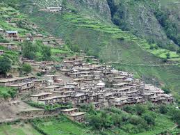
Til is a beautiful village like any other village in Limi Valley. The culture and people life style here is like similar Tibetan people. There is a Chorten to the village gateway. They conserve former Tibetan culture, they wear their traditional dresses, men wear a long thick brown coat, with one sleeve down and the women wear a long brown or blue dress with a colorful apron made from yak wool. They have long colorful cape to keep their heads worm. 0n at tent and get a sound sleep.
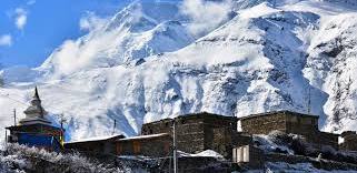
Day 13 : Til to Halji (3660 m) 3 – 4 hours
The thirteen day of trek is less work and more fun relatively easy and smooth walk. You will walk few hours to get in Halji and have spare daylight, by the time this give you opportunity to wander around the village and have a look around the monasteries. The Limi River fills Karnali’s shoes as Limi River accompanies your trail. Keep an eye around because you never know when those highly endangered species are going to show up. Please, do not miss out such an opportunity. With luck on your side, you might come across mountain goats, deer, snow leopards, and even blue sheep. This place is behind the Himalaya treasure. The trail goes through the Chörten and big Mani wall, Mani walls are low walls built up with many stones with holy mantras and Buddhist deities carved on them. The Rinchenling Gompa is affiliated to Kagyugpa Lineage; it is the holiest Monastery in the region built on 14th century and is also the centre of religious activities in the Limi Valley. The main hall has a well decorated idol of Shakyamuni Buddha. Other rooms have smaller statues, a completed version of Kenjur (the Buddhist scripture), masks and costumes used during different cultural carnivals. They do not charge you for the entrance but you have to pay 500 NRS for the picture. Your stay overnight will be at one of the tea houses or your own tented camp.
Day 14 : Halji to Jang (3930 m), 4 – 5 hours
This is relatively a relaxed trek of about five hours. Most of the time, the path goes through the Limi river bank. The companionship of Limi River makes every single second worthwhile. Jang is the third and the last village of Limi Valley. And like all other village it is nothing short of dignity, surprises and beauty. As far as Jang is from the modern hustle and bustle and as free as it is from the modernism, Tibetan cultures come alive here at their purest. Here is a beautiful Gompa which you can visit after paid 500 NRS. You can stay night in the tea house also.
Day 15 : Jang to Talung (4370 m) 7 – 8 hours
Today is best part of the trek, that until Kermi through the wilderness trail no human settlements and most fantastic landscapes. The trail gets harder at times and crossing few wooden brides on the rivers and streams. The trail remains slow and steady goes up until Talang. You will be staying in tent for overnight at Talang.
Day 16 : Talung to Shinjungma (3620m), across Nyalu La (4940 m) 7 – 8 hours
Today is day sixteenth of the trek, this will take you at highest point of the tour. Nyalu La pass is highest point with 5,001 meters from the sea level. Walking at such high elevation with tiny trail is an adventure itself even though, you will enjoy with beautiful mountain and nature. Snowy trail, 360 degree view of Humla and Tibet, the glimpse of glorious mountains like Mount Saipal (7031 m), and Mount Kailash (6714 m) make you unforgettable trip. Taking some pictures on the top, rest of the path climbs down after you across the pass. The altitude fall down quickly, at 4630 meters elevation there is a tranquil Selma Tso Lake. The downward slope continues on its course all the way down to Shinjungma , where you camp setting for overnight stay. The vegetation and climate is changing very much, the Sali River, steep slopes, Mount Kailash.
Day 17 : Shinjungma to Kermi (2670 m) 7 – 8 hours
Your first day walking in the human settlements in days after your trek started. You will get back to Kermi Village today with 3,000 meters below altitude after long time. But the walk does not get any better due to you will be treading on the solid grounds amidst pine and birch trees and Sali River by your side. The trail takes you to the Karnali River and your parade heads eastbound. You can relax at hot spring; dip your tired body into the hot pound before seeing off your day in a tented camp.
Day 18 : Kermi to Simikot (2950 m), 6 – 7 hours
The day begins with few ups and downs along the road and nice landscape. The trail is smooth up to Darapuri (2300 m) and Majgaon(2290 m) you will enjoy very much. Then, after Majgaon the trail decides to turn aggressive. It takes two hours walk up the hill from the Karnali River until you reach a pass at the height of 3,000 meters. From there on, it is another half an hour walks to get in Simikot. You have hot water proper shower after long time and walking around the market. You will be spent the night in a tent.
Day 19 : Fly Simikot to Nepalgunj to Kathmandu
You trip end on day 18th, with Limi Valley end. Back to Kathmandu via Nepalgunj is long way due to few flights, unpredictable weather and geographic condition. You will collect with some life long memories during this tour. Your flight will be earliest possible in the morning to make sure in schedule. During spare time, you will scan through the market in Thamel for some souvenir. We will provide you suite cozy hotel after about two weeks and half tip.
Day 20 : Departure your home destination.
Your trip concludes airport transportation fly for your won destinations from Tribhuvan International Airport.
Trip Duration: 20 days.
Highest Altitude: Limi Humla Valley Trek (4,560 m).
Grade: Challenging.
Transportation: Private Vehicle, Domestic Flight.
Accommodation: Semi Lodge/ or fully Camping.
Highest Point: Limi Humla Valley Trek (4,560 m).
Type of Tour: Trekking, Hiking, Walking, Culture.
Trekking Hour: Approximately 5-6 hours each day.
Trekking Duration Total Days: 20 Days.
Limi Valley Trek is located at the western part of Nepal. Most of the people in Humla District follows Tibetan Culture. The Limi Valley trek was only opened to foreigners in 2002 as this area borders on Tibet in the far west of Nepal. It follows an ancient trading and pilgrim route over challenging trails and high passes.This is one of last true wilderness area, tucked away inside. Humla District where century old Buddhist traditions still exist and the people of the north-western part of the district are more like their Tibetan neighbors to the north than their Hindu neighbors in the south-east part of the district. On this trek, not only can hikers see the great mountains of Saipal, Byas, Rishi, Api, Kanjirowa, and Kanti in Nepal, but also the revered holy Mount Kailash across the border in Tibet.
Possible wildlife on view includes marmot, wolf, wild yak, and Himalayan black bears. Of the rare mammals, snow leopards and blue sheep are known to live in this area. This amazing trek highlights a different side of Nepal than that seen in some of the more usual trekking routes. It also gives a glimpse into the mystical land of Tibet.
The major highlight of Limi Valley Trek involves the trek up to Gyuo Kharka 5150 m, which caters an opportunity to sight the view that would make you fall in love with the beauty of nature. From the top of this pass, we see breathtaking beauty of alpine nature that include Himalayas like Saipal (7031 m), Byas Rishi, Api, Kanjirowa, Kanti, Gorakh Himalayas. The beauty nature from here stretches until the Himalayan Peaks in Tibet, which include sacred Peak, Mt. Kailash and Gorlamdanda. The view of Lake Mansarovar lying at the foothills of Kailash is enchanting view to observe from the acme.
COST INCLUDES:
All ground transport by private vehicle.
Trekking Lodge /Tea House Accommodations throughout the trek.
Breakfast, Lunch and Dinner during Humla limi valley trek.
All necessary paper works for special humla trekking permit, National Park Entry Permit and TIMS card.
A highly experience and knowledgeable, friendly , English speaking well trained, Government License holder guide with his salary, food, drinks, accommodation, transport to and from, insurance.
Friendly and helpful porters with proper walking equipment, his salary, foods, accommodation and insurance (one porter for two people).
Comprehensive medical box (first aid kit will be available).
Arrangement of Emergency Helicopter service (paid by your Travel Insurance company).
Government taxes and official expenses.
Emergency life saver oxygen and mask support.
Kathmandu sightseeing tour with private vehicle.
COST EXCLUDES:
International Airfare from and to Kathmandu.
Nepal entry visa fee (you may easily issue the visa on arrival at Tribhuwan International
Your Travel and Medical Insurance.
Meals whilst you are in Kathmandu Lunch and Dinner as per itinerary.
Your Personal Expenses and trekking equipment for the trek.
All the alcoholic and non alcoholic cold and hot drinks on trek ( i.e. those you choose to purchase along the way and during evenings in the Tea Houses)
All desserts sweet things like chocolate, cake, pie, pudding.
Hot and Cold drinks ,hot shower and battery charging on the tea houses.
Tips for the guide, porter and driver (Tipping is expected)
Kathmandu sightseeing entrance fees.
Excess baggage more than 12 kg.from Nepaljung to simikot flight. (If you have extra baggage you can leave in Kathmandu with full safety)
EQUIPMENT LIST
Nepal Trekking Equipment List
This piece info is creating data on consumer goods and equipment needs, For those that would love an extra detailed discussion for equipment for Nepalese Himalayan Trek.
The following equipment list is required for Nepal Trekking and climbing and a list, you have to have suggested equipment just have with you, however, that you just might have your own personal first choice equipment which can be equally as appropriate
Footwear
Legwear
Body
Head/Hands
Other items
Optional items
Recommended Mountaineering Kit
In addition to the items mentioned above for trekking, the following is a list of the additional specialist items which are required for the trekking peaks.
Plastic or leather mountaineering boots, with gaiters and crampons that have been tested for a good fit.
Peak Climbing
If you have any inquiry the get a quick service.